- Smart City/Mobility Business HOME
- Search by use case
-
Search by product/service

- event·
seminar -
Case studies and columns
- Inquiry

Synspective, a one-stop solution business that utilizes satellite observation data, aims to realize a “learning world” that expands human possibilities through new data and technology and makes steady progress.
In this article, Motoyuki Arai, Representative Board Director CEO of the company, talks about the concepts and possibilities of dynamic planning made possible by data obtained from small SAR satellite constellations, and solution projects for building resilient cities and disaster response. We will listen to the company's vision and the worldview they want to realize. We will then consider how the company's business results will create synergies and co-create with Macnica 's business.
What are the future trends in urban infrastructure development? Towards harmonious infrastructure construction
Countries and companies around the world are paying attention to the SDGs (Sustainable Development Goals) advocated by the United Nations, and are showing movements in step with those goals. Under such circumstances, the word resilience has come to be used frequently. This word, which means strong resilience, is now being applied to urban development.
Even if a city falls into dysfunction due to disasters or human forces, in order to restore its functions with strong resilience, it is necessary not to build strong bridges, roads, and facilities each time, but to harmonize over a wide area. It is necessary to build a well-developed infrastructure and restore the city at a high speed.
This should be readily understood by those living in Japan who have experienced many large-scale natural disasters. It may not be possible to minimize the risk of damage just by having solid infrastructure scattered around. I have. It is said that urban development in the future must not only be robust, but also flexible and optimal in stages. In other words, even if a certain degree of destruction occurs, there is a need for the ability to create infrastructure that can cope with the situation.
Macnica supports demonstration experiments and regular operation of autonomous driving throughout Japan. As a result of this effort, we have also developed an in-house sensor data collection terminal and are conducting demonstrations to acquire the latest road conditions as data from vehicles actually driving. By utilizing this technology, we should be able to contribute not only to the development of autonomous driving cars, but also to the creation of a harmonious infrastructure by acquiring information on roads and nearby facilities. In normal times, by understanding not only the road conditions but also the installation status of signs and other equipment, manual maintenance work can be made more efficient, and in the event of a disaster, it is possible to quickly assess the level of danger again. It will be possible.
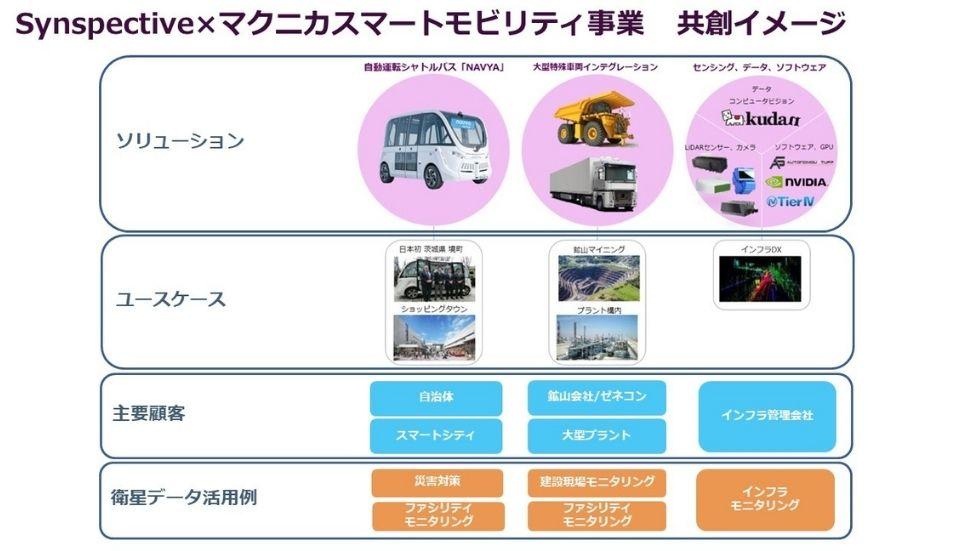
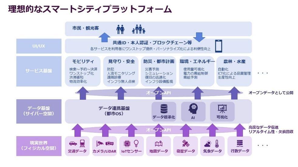
Macnica mainly handles ground data such as road infrastructure and surrounding environment, while Synspective mainly handles satellite data obtained from small radar satellites (SAR satellites). Currently, Macnica and Synspective have begun collaborating to combine mutually owned terrestrial data and satellite data and utilize it in various use cases such as smart cities and construction sites.
Utilization of satellite data by Synspective
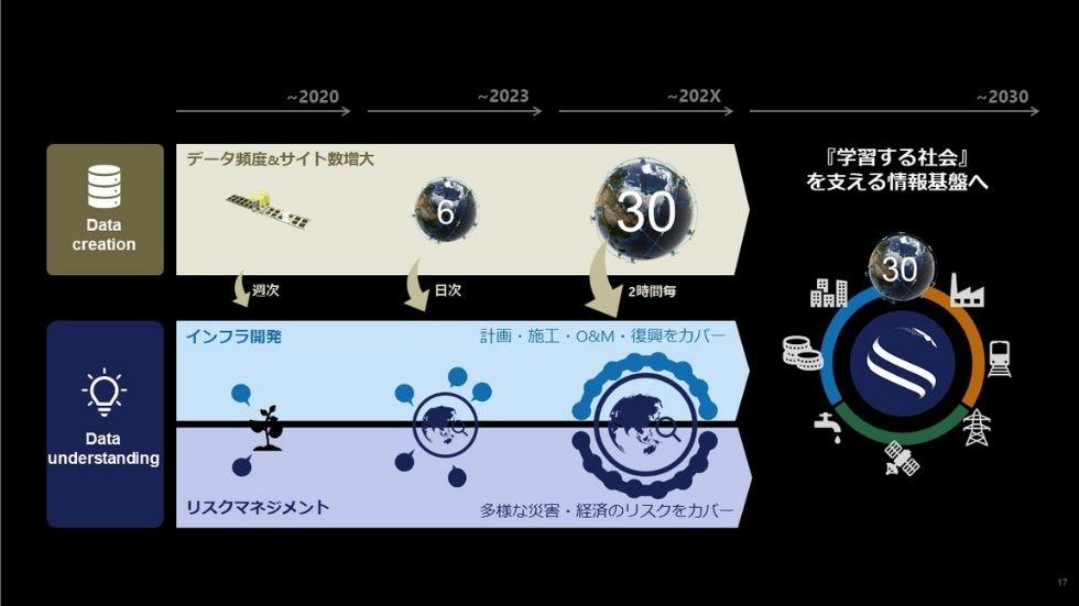
Let me explain Synspective here. The company is a startup founded in 2018, applying the results of the Cabinet Office "ImPACT" program to develop SAR (Synthetic Aperture Radar) satellites, sell observed data, and develop solutions that utilize satellite data and machine learning. We also develop and provide The company currently has two satellites, but plans to have more than 30 available by 2030.
Mr. Arai of the company said, "If we can use six satellites, we will be able to update the surface data of each region, which is currently acquired weekly, on a daily basis. We will be able to take global data from , analyze it and deliver results within three hours."
SAR satellites are equipped with radar sensors that radiate radio waves to the surface of the earth to determine the shape of buildings and roads, as well as topography with a resolution of 1 meter. Such high-resolution data can be acquired in just a few seconds, for example, in a range that covers almost the entire Tokyo metropolitan area. Furthermore, SAR satellite sensors are not affected by the weather, and can transmit data from areas where typhoons are occurring.
If 30 satellites are orbited, it will be possible to analyze the latest data of a fairly wide area of the earth's surface in about 3 hours after a major disaster occurs. If that happens, we will be able to ascertain the route to the safest evacuation site and areas at risk of secondary disasters. By utilizing this data analysis function and AI algorithms, it will be possible to quickly issue evacuation orders for a wide area that straddles multiple prefectures.
In fact, Synspective has successfully conducted various image capturing demonstration experiments, and even if it is limited to 2021, it will be used in various fields such as prediction of ground subsidence, use in overseas transportation infrastructure projects, and data utilization in the water supply and sewerage field in Japan. Efforts have started.
For example, in the construction of solar panels, it will be possible to quickly respond to orders such as "a place that is less prone to damage such as ground subsidence and has the highest energy efficiency in a year."
We are also collaborating with JICA (Japan International Cooperation Agency) to detect new disaster risk areas in Guatemala. As an overall trend in Guatemala City, we confirmed the location of local subsidence phenomenon and the risk of subsidence/landslide, and understood that it showed a change in millimeters. In addition, detailed analysis is performed on points that show characteristic fluctuation trends, and new cave-in risk points that could not be confirmed by conventional human survey methods are found.
A true “grand design” for city planning
Up until now, urban infrastructure was not built with a “grand design” based on accurate data. For example, even if we tried to optimize the infrastructure of the city of Tokyo, it was too large to grasp the data, much less to obtain real-time change data. In other words, no matter how much we tried to create data-driven measures, we could not obtain the data itself.
However, if the operation of SAR satellites further expands in the future and it becomes possible to acquire data from all over the world at low cost, the story will change. By incorporating and analyzing external data, such as simulating all kinds of disasters and crisis situations based on satellite data, it is no longer a dream to create cities that are optimized for resilience.
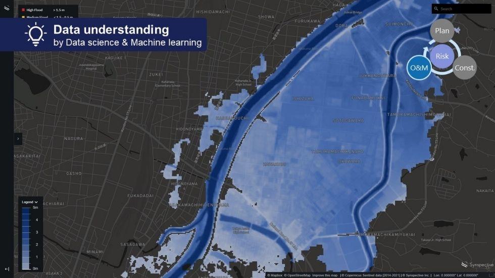
©Mapbox, ©OpenStreetMap Improve this map,
©Copernicus sentinel data [2014-2021], ©Synspective Inc.
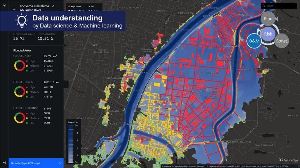
©Mapbox, ©OpenStreetMap Improve this map,
©Copernicus sentinel data [2014-2021], ©Synspective Inc.
As in the case of Guatemala, data-driven risk assessment makes it possible to understand facts that could not be understood with personal skills. Also, in cities in mature countries such as Tokyo, where various interests are involved, there are cases where it is difficult to reach a consensus for optimized urban development. However, by promoting data-driven measures, an environment that makes it easier to make adjustments should be established.
By analyzing high-resolution data obtained from satellites, such as flooding of rivers and the risk of collapse due to earthquakes, there is a possibility that existing hazard information will be significantly updated, and more people will be able to obtain accurate information. You will be able to avoid risks based on information.
Synspective not only provides satellite data as is, but can also analyze and present, for example, the extent to which ground subsidence progresses. Based on such analytical information, we will be able to make appropriate infrastructure investments, and it should be easier to raise funds in advance.
Optimal urban development must have a strong economic foundation, and accurate data must be the basis for discussion and prioritization of development. Hmm. Data from satellites will be very useful for such applications.
Combination of pinpoint sensor data and extensive satellite data
In this way, the data provided by Synspective and the analytical information based on it bring many benefits. By combining this information with data on roads and their surroundings provided by Macnica, we expect even more value to be created.
Information from sensors installed in automobiles is pinpoint and real-time information. In other words, it is like introducing an IoT system into the urban infrastructure. Since it is activated after a disaster occurs, it is possible to obtain accurate information without being destroyed by a disaster like sensors installed in advance.
Such sensor information is useful for further digging into the information from the satellite and grasping the situation in more detail. Combining broadly mapped municipality-level surface data with sensory information from camera footage and vibrations will give us a concrete understanding of what needs to be prioritized right now.
In the event of a disaster, risk information for a wide area can be grasped from satellite data, and by pinpointing areas where danger is likely to occur using autonomous driving cars and drones, etc., more detailed information can be provided to citizens. Information can be provided, and the probability of avoiding danger increases.
In addition to disasters, it is possible to explain the value of buildings in an easy-to-understand manner by providing detailed images and sensor data of locations that have been identified as "optimal locations for construction" by satellite data. It will be useful for raising funds and increasing profits after construction.
By combining satellite data and pinpoint sensor data in this way, the possibility of creating new value will expand. In order to make it easier to create such value, it is also important to build a platform for data utilization and attract various users.
Building and operating such platforms is Macnica 's greatest strength. By utilizing the cloud, it will be easier to obtain analytical data using highly accurate information, and the number of users will also expand globally.
Inquiry
If you have any questions orconcerns regarding this matter, please contact us from the following.